A Look At Stone Harbor Point (Hereford Inlet)
This is a close-up of the previous 1991 image.
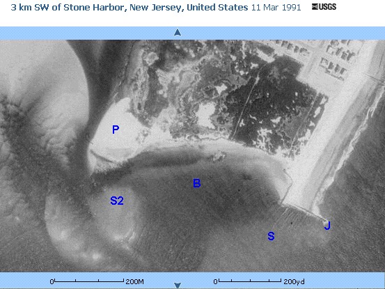
We windsurfed this site circa 1986-1988. This image shows the point ("P") as I remember it, complete with the sandbar ("S"), the interior bay ("B"), and a secondary sandbar ("S2").
The beauty of the point was the interior bay, which provided a relatively safe, shallow place in which to practice in the small waves and to execute turns back towards the ocean. The waves would break in the ocean outside the sandbar, and then reform and break a second time in the interior bay. What a thrill - I recall several rides on waves that broke twice.
This 1991 image shows that the point and beach line of the interior bay has been eaten away by the water, more so than in the earlier windsurfing years. In earlier years, there was heavy vegetation extending nearly all the way to the point. That vegetation also extended to the edge of the water of the interior bay, providing little or no beach. The water lapped up against an exposed, ancient layer of peat close to the vegetation.
By the time of this 1991 image, the point had been shortened by about half a city block, and what was left was cleared of vegetation and the old peat shoreline. Notice how far the water has 'cut in' behind the rock jetty (jetty = "J"), a process that had been in place during the late 1980's.
This 1991 image must have been taken at high tide and clearly shows waves crossing the sandbar and entering the interior bay. This is somwhat deceiving. By 1989, the sandbar - and probably also the interior bay, were too shallow to windsurf.
By the late 1980's, Hereford Inlet had become as large as it could remain. Though the point would continue to be eaten away in the 1990's, new sand deposits were filling in the interior bay and sandbar, eventually creating a new large point by 2003, with some help in 2002/2003 by man.